October 31st, 2022
79. Where did Israel cross the Red Sea, and where is Mount Sinai?
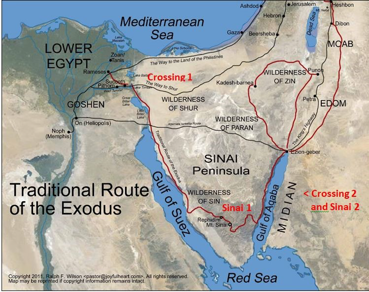
For centuries the predominant answers to these two questions have been that Israel crossed the Red Sea near the eastern border of ancient Egypt, somewhere near the spot where the present Suez Canal meets the Gulf of Suez (Crossing 1 on the map). The Gulf of Suez is the western arm of the large body of water which we today call the Red Sea. Mount Sinai is then located in the south central part of the Sinai Peninsula, at one of the peaks near the present-day Saint Catherine’s monastery (Sinai 1).
Recently a minority of writers have claimed that Israel crossed the Red Sea on the eastern shore of the Sinai Peninsula, at the Gulf of Aqaba, 250 miles from the eastern part of the Nile Delta (Crossing 2 and Sinai 2). Three pillars of this theory are 1) that the Red Sea or Sea of Reeds always refers to the Gulf of Aqaba; 2) that Mount Sinai must be in Arabia, not in the Sinai Peninsula, and 3) that Mount Sinai is in Midian which is in Saudi Arabia.
The Term Red Sea
Our modern term the Red Sea is not a literal translation of the Hebrew term Yam Suph, which is usually translated as the Sea of Reeds. (With different vowel pointing of the Hebrew, some read Yam Suph as Sea of the End or Sea of Destruction.) Our English term Red Sea is a translation of the Greek Erythra Thallasa and the Latin Mare Rubrum, terms which occur some 800 times in the classical writers, in which these terms may refer to any of the arms that run off the Indian Ocean, including the Gulf of Suez, the Gulf of Aqaba, and branches of that sea as far away as the Persian Gulf and the Bay of Bengal.
While the term Red Sea can indeed refer to the Gulf of Aqaba, which is east of the Sinai Peninsula (Yam Suph in 1 Kings 9:26 is the Gulf of Aqaba), it can also refer to the Gulf of Suez, west of the Sinai Peninsula. In Exodus 10:19 the Lord ends the eighth plague, the plague of locusts, by bringing a strong wind that drove the locusts into the Red Sea. This must refer to the Gulf of Suez. It can hardly be the Gulf of Aqaba, 250 miles away. The usage of the term Red Sea thus allows it to refer to the Gulf of Suez. This conclusion invalidates one of the chief objections against the traditional identification which locates Israel’s crossing of the sea on the eastern border of ancient Egypt.
The Genesis Apocryphon, one of the Dead Sea Scrolls, supports this wide use of the term Red Sea and connects the Red Sea with the Yam Suph.

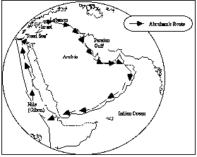
I, Abram, went out to travel around and to see the land. I began to travel around from the Giḥon River (the Nile), and I went along the side of the (Mediterranean) Sea until I arrived at Mt. Taurus. Then I traveled away from the side of this great sea of salt, and I went along the east side of Mt. Taurus through the breadth of the land until I arrived at the Euphrates River. I traveled along the side of the Euphrates until I reached the Red Sea toward the east (the Persian Gulf). I continued going along the side of the Red Sea until I reached the inlet (lit. “tongue”) of the Sea of Reeds which emerges from the Red Sea (circumnavigation of the Arabian Peninsula), and then I traveled toward the south until I arrived at the Giḥon River.
The Red Sea here runs all the way around the Arabian Peninsula and the Yam Suph is an extension of it.
Location of the Crossing and the Mountain
The Sinai was not considered part of Egypt proper. It was called the land of Mefkat. The crossing of the sea therefore must be on the eastern border of Egypt proper, near Goshen, not far away on the east side of the Sinai wilderness.
All the sites mentioned in Exodus 13 and 14 before Israel’s crossing of the sea seem to lie within the eastern part of the Delta in the land of Egypt, though the identification of several of them is uncertain. The crossing seems to follow fairly quickly after the Passover, and so it must be quite near to Goshen. Deuteronomy 33:5 mentions only two camps (Sukkoth and Etham) before Israel arrives at the seashore. As he gets ready to pursue Israel, Pharaoh says that Israel is wandering around in the land (Exodus 14:3). Would he say this if they were 250 miles away on the shore of the Gulf of Aqaba on the far side of the Sinai wilderness? This evidence points to a crossing of the sea on the eastern border of Egypt proper, not to a crossing hundreds of miles to the east.
There are three main routes considered as possibilities for Israel’s travel across Sinai: northern, central, and southern. The northern route is the Way of Shur, about 30 miles south of the Mediterranean coastline. Today it runs from Ismailiya, on the Suez Canal, to Beersheba. The central route follows the Darb el-Haj (as its name implies, the route to Mecca) that today runs from Cairo to Elat (Ezion Geber) via the Mitla Pass. The southern route runs south along the Gulf of Suez, turns inland at Wadi Feiran (identified with the biblical Rephidim), crosses the mountain range by the Monastery of St. Catherine and then turns north toward Elat and Kadesh Barnea.
After the crossing, Israel finds itself in the Wilderness of Shur (Exodus 15:22). Shur lies between Canaan and Egypt on a direct route from Canaan to Egypt. In Genesis 16:7 Hagar passes through the Wilderness of Shur on her flight from southern Canaan to Egypt. In 1 Samuel 15:7 Shur borders Egypt on the east.
If Israel was heading for a Mount Sinai in Saudi Arabia, they could have gone directly east through the Wilderness of Paran to Elat/Ezion Geber at the northern tip of the Gulf of Aqaba and then traveled down along the west coast of Arabia. It would make no sense for them to turn south and trap themselves against the Gulf of Aqaba. The explanation for this strange act by proponents of an Arabian Mount Sinai is that the Lord ordered the detour so they would be trapped and Pharaoh would be provoked to pursue them. But this location seems too far away from Egypt to be plausible. Israel would have to travel over 200 miles to get to the Gulf of Aqaba. It would then take some days for word to get back to Pharaoh. He then had to gather his army and travel across over 200 miles of wilderness to catch Israel. Some proponents of an Arabian Mount Sinai place the crossing of the sea even further south, which would increase the difficulty of this problem. Also the depth of the middle of the Gulf of Aqaba averages 900 meters with steep descents. This does not seem to fit the description of the crossing site.
The traditional route of Israel during the forty years makes good geographical sense if Mount Sinai is in the southern Sinai Peninsula. From Mount Sinai Israel goes north to Kadesh on the southern border of the land of Canaan, but they fail to enter the land from that direction because of their unbelief. At the end of the forty years they are again at Kadesh. Now the plan is to invade Canaan from the east near Jericho. To get there they must make a long detour around the west and east borders of Edom. None of the later movements to and from Kadesh make geographical sense if Mount Sinai is in Saudi Arabia. They could have just traveled to Canaan on the east side of the Dead Sea.
Later Tradition
In 2 Kings 19 when Elijah is fleeing from Jezebel, he heads south through Judah to Beersheba, and from there he goes a day’s journey into the Sinai wilderness. From there he heads to Mount Sinai (Horeb). The text seems to assume that its readers will be familiar with the general location of Sinai/Horeb. The geographical clues in the text support a location for Mount Sinai in the Sinai Peninsula.
There is evidence that prior to 100 BC, well before the Christian monastic period, Jewish sages and early Jewish pilgrims already identified Jebel Musa as Mount Sinai, and this identification was later adopted by Christian pilgrims. Other early pilgrims chose other peaks in the vicinity, but they were all searching in the same neighborhood. A number of Christian hermit monks settled on nearby Mount Serbal, considering it to be the biblical mountain. Others settled on Mount Catherine since it was the highest peak in the area.
In Christian tradition, the identification became firmly attached to the plain below Jebel Musa when Helena, mother of Constantine, chose it as a site for a church around 325 AD. This site was further supported by the account of the pilgrim Egeria, who visited the site later in the 4th century AD, and when Saint Catherine’s Monastery was built there in the 6th century AD by Justinian.
Countering Objections
The objection that Paul’s statement in Galatians 4:25 which says that Mount Sinai was in Arabia rules out the Sinai Peninsula as the location of Mount Sinai is not valid. The Sinai Peninsula was included in the Roman province Arabia Petraea or Petrea (Latin: Provincia Arabia; Greek: Ἐπαρχία Πετραίας Ἀραβίας). This province is distinguished from Arabia proper, known as Arabia Deserta and Arabia Felix.
In Exodus 2 and 3 Moses meets a priest of Midian in the vicinity of Mount Sinai. The heartland of the nomadic Midianites territory seems to be in northwest Arabia, but they roamed widely, and like the Edomites and Arabs, they could be found both east and west of the Arabah that runs from the Dead Sea to the Gulf of Aqaba (Gulf of Elat). Presence of Midianites somewhere near Mount Sinai does not rule out a location for Mount Sinai in the Sinai Peninsula. In addition, Exodus 18:27 and Numbers 10:30 imply that the area around Mount Sinai was not Jethro’s home territory.
Conclusions
There is no compelling reason to move the crossing of the sea to the Gulf of Aqaba or to locate Mount Sinai in Saudi Arabia. The traditional locations still seem to be more likely, although neither of them can be pinned to a precise location.
Mount Sinai could be one of a number of peaks in the same range as the present-day Mount Sinai (Jebel Musa).
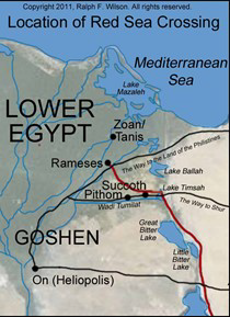
The terrain around the south end of the Suez Canal may be quite different today than it was 3500 years ago, due to changing sea levels and changes caused by the creation of the canal, so it is impossible to assume that the features of the area today are close to those of Moses’ time.
There are several bodies of water north of the present-day tip of the Gulf of Suez that are plausible sites for the location of the crossing. These sites also offer a possible correlation with the name Sea of Reeds. The sea itself may have extended further north than it does today. The present lakes in the vicinity are quite deep. Thus, there are a number of plausible candidates, but none of them can be pinpointed as the site.
The Israelites and their neighbors thought of the world as having two great Seas or Oceans. The inner sea (the Mediterranean) was surrounded by the lands they were most familiar with. They were aware of another Ocean that ran around the outside of their world. By the middle of Old Testament times they knew quite a bit about these inner and outer Oceans. They were aware of the Red Sea, the Indian Ocean, and the Persia Gulf as arms of the outer ocean. They also knew there was an ocean outside the Pillars of Hercules (the Atlantic). Herodotus reports that by the 5th century BC the Phoenicians were aware that this ocean ran all the way around Africa, and that they had circumnavigated Africa.
The effect of the biblical reference to the place of the crossing in Exodus 13:17-18 is to disassociate the crossing site from the inner ocean (the Mediterranean) and to connect it with the outer ocean (the Red Sea).
Another reason to be very cautious about adopting the Mount Sinai in Arabia theory in a general reference book like the EHV Study Bible is that it was popularized in part by the discredited work of Ron Wyatt, whose work and claims are rejected by archaeologists from across the whole spectrum of scholars. This does not in itself prove that the theory is wrong, but should make us very cautious about turning to it without compelling reasons to do so.
The locations of the crossing of the sea and Mount Sinai cannot be identified with any degree of certainty, but if one simply triangulates all of the geographical references that pertain to the crossing of the sea and Mount Sinai, they all point to the north end of the Gulf of Suez and to the mountains of south central Sinai. Even if Helena’s informants were simply guessing at the location, they were making an informed guess. None of the objections to the traditional locations are compelling. So there is no reason to abandon the traditional view. In dubious cases, it is wise to stay with tradition. “Be not the first by whom the new is tried.”
The crossing of the sea and the giving of the Law at Sinai were real historical events at real geographical places. The important thing is not the precise location, but the reality of the events and their meaning.